The seminar 'Map generalization and multiple-/vario-scale representations', was held to close the STW project Vario-scale Geo-information.
At the Faculty of Architecture, Delft University of Technology, The Netherlands.
On Wednesday, December 6, 2017 from 09:00 to 12:30.
Slides of the presentations can be found below.
![]()
![]()
![]()
![]()
Location
Delft University of Technology
Faculty of Architecture and the Built Environment
Julianalaan 134
2628 BL Delft
The Netherlands
Berlage rooms
Programme Outline
| 9:00 | Session 1 |
|---|---|
| Dirk Burghardt (TU Dresden, Germany): Generalisation and Multiple Representation of Location-Based Social Media Data | |
| Elmar Eisemann (TU Delft, Computer Graphics): Multiple levels of detail in Computer Graphics | |
| Martijn Meijers (TU Delft, GIS technology): Web-based vario-scale system architecture supporting smooth/animated interaction | |
| 10:30 | Coffee |
| 11:00 | Session 2 |
| Lars Harrie (Lund University, Sweden): A vision for vario-scale reference maps integrated with thematic maps | |
| Rod Thompson (Queensland, Australia): Managing the huge range of map scales in the practice of the Queensland Government | |
| Radan Šuba (WAG, Czech Republic): (Vario-scale Shenzhen and) Extension of tGAP/SSC creation with scale dependent actions | |
| 12:30 | Lunch (optional) |
Programme Details
- Dirk Burghardt (TU Dresden, Germany): Generalisation and Multiple Representation of Location-Based Social Media Data
-
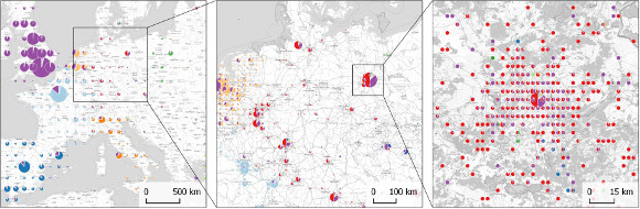
Generalisation and Multiple Representation encompass well established concepts and methods to enable the automated derivation of smaller scale maps. The presentation will show the potential of applying them for the scale-dependent visual analysis and presentation of user-generated, spatial content in general and location-based social media data in particular. The original development of methods and models such as generalisation operators or digital landscape / cartographic models were driven by the requirements of National Mapping Agencies with focus on topographic map production. Here an attempt is made to rank generalisation operators according to their relevance for the derivation of general and categorised information out of the individual social media data and second to create readable maps without clutter.
Multiple representations of location-based social media data has the potential to support multi-scale visual analysis on different spatial and semantic granularities. Furthermore it could be interpreted as concept of representing various perceptions of different user groups. Two main strategies can be distinguished in order to generate the multi-scale views, on the one hand data driven approaches such as hierarchical clustering and on the other hand space partition approaches such as hierarchical grid-based tessellations. Both strategies are illustrated with applications for the visual analysis of location-based social media data.
- Elmar Eisemann (TU Delft, Computer Graphics): Multiple levels of detail in Computer Graphics
-
In this talk, we will cover recent work for large-scale data visualization and its use in practical applications. For many applications, the involved data sets reach sizes that make it very difficult to work with. We present modern approaches to handle complex data by relying on structures and algorithms that enable an adaptation of the level of detail. The talk will include examples from visual analytics, virtual reality, and mobile computing.
- Martijn Meijers (TU Delft, GIS technology): Web-based vario-scale system architecture supporting smooth/animated interaction
-
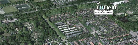
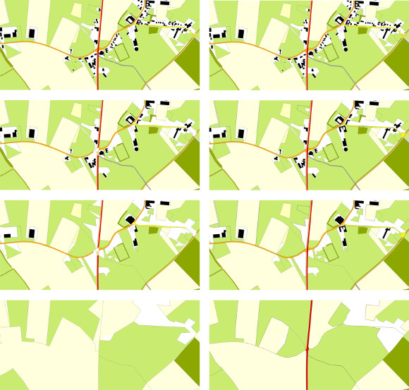
The ‘Space Scale Cube’ (SSC) stores the result of vario-scale map generalisation operations, including smooth transitions. The third dimension is used to describe the transitions in a geometric fashion for objects at different levels of detail/map scales, where also the boundaries of objects can be smoothly changing. Many generalisation operations fit in this structure. The 3D model used for deriving 2D maps can subsequently be used in a (mobile) client, where powerful graphics hardware is available these days. This talk gives an overview of the architecture for use of smooth SSC data over the web. First we describe how data is organised in blocks and can be used for an efficient client-server setup. Second, we give insights in how our implementation makes available smooth and animated zoom and pan operations in our client. Note, the prototype is available under WebGL demo on this website.
- Lars Harrie (Lund University, Sweden): A vision for vario-scale reference maps integrated with thematic maps
-
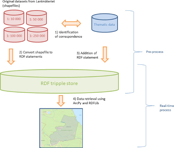
There are several challenges of storing a base map in vario-scale representation. One such challenge is the (real-time) data integration with other data. In this presentation we describe a vision of how to integrate thematic data with a vario-scale base map.
The presentation starts with a description of a current project at Lund University, Sweden, of integration of a multiple representation base map and thematic data using a relative positioning approach (see short description in Huang et al., 2016). The basic idea is that there are explicit links stored between the thematic data objects and objects in the base map, which synchronize the scale dependent representations of the two data sources. The explicit links are stored using Linked data (RDF) which in turn enables real time services with perfect data matching at all scale ranges. The second part of the presentation discusses how this technique can be extended for enabling integration with a vario-scale database. The basic approach could be the same as for a multiple representation map but it additionally requires an extended ontology for handling the geometry representations in the vario-scale base map.
- Rod Thompson (Queensland, Australia): Managing the huge range of map scales in the practice of the Queensland Government
-
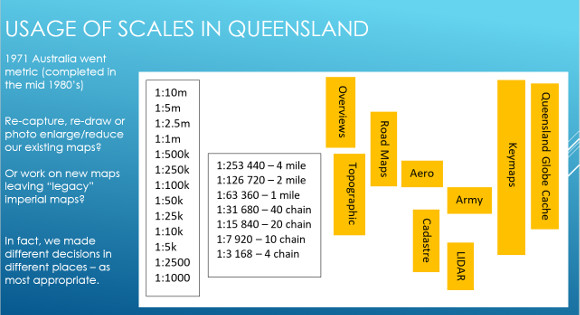
The state of Queensland is geographically large but the level of detail required of geographic data in the highly populated parts is the same as anywhere else in the world. The smallest generally useful scale is about 1:10 000 000 – which puts the whole of Queensland on a sheet of A4 paper. By contrast, for the areas needing detail, “bigger is better”, but 1:1000 usually considered the largest practical scale. In the Cadastre of Queensland, the largest scale in general use is 1:2500.
In 1945, a conference of the Commonwealth and State Government's Surveyors General led to the formation of the National Mapping Council (NMC) to coordinate mapping activities in Australia in relation to the Federal Government, Military and State Governments and determine minimum accuracy standards. All mapping in Australia was based on the Imperial system of measurement (our British heritage).
This created a complication – that is the conversion of Australian weights and measures to metric between 1971 and 1988, was just a bit early for the other big conversion – to digital mapping. As a result, we were in the difficult position of having to either re-capture, re-draw or photo enlarge/reduce our existing published maps, or work on new maps in the areas that were on programme for capture, leaving the imperial scales as the “best available” in other areas.
Queensland's Topographic Mapping program was limited to 1:25,000 and larger. (Imperial 40 chain and larger) National Mapping managed the 1:250,000 and 1:100,000 topographic mapping. The Army looked after 1:50,000 mapping replacing the old 1 mile series. The Army's interest is in defence so that limited their mapping to areas of strategic significance.
Queensland's topographic mapping programs were oriented towards development (agricultural, mineral etc), hence the larger scales: 1:25,000, 1:10,000, 1:2,500. While conventional topographic maps were produced at these scales, the Department changed its focus to “orthophoto” mapping – i.e. rectified aerial photos to align to the Australian Map Grid with a contour overlay and some annotation.
In recent years, modern technology, such capture of LIDAR imagery by the ROAMES project (now part of Fugro), has been in progress for the purpose of maintaining the electricity supply network. This is feeding in highly detailed and accurate topographic date in an ever-increasing region of coverage. As this area becomes significant, there will be the need for sophisticated generalisation to upgrade the smaller scales.
- Radan Šuba (WAG, Czech Republic): (Vario-scale Shenzhen and) Extension of tGAP/SSC creation with scale dependent actions
-
In vario-scale research there is a demand for a steering algorithm which guarantees well generated map content; An algorithm providing a global criterion together with enough flexibility necessary for different map features. Our recent research has provided key elements towards such an algorithm and will be demonstrated in the presentation. It is based on the idea to relate decisions to the target scale, inspired by the ScaleMaster framework for utilization of generalization operations (Touya & Girres, 2013). More specific, during the generalization process, for each object which should be generalized we calculate the target scale. This, together with its feature class and geometrical configuration provides information which generalization operation is to be performed. With our scale dependent framework, it is easier to orchestrate the actions and specify which operations to perform for which scale range. We found this framework very useful during our research visit of Shenzhen, China where testing and tuning of the generalization process were necessary for Chinese input data.